5 Neolithic Communities
Skara Brae

John Lord | CC BY 2.0
Skara Brae is a Neolithic Age site, consisting of ten stone structures, near the Bay of Skaill, Orkney, Scotland. Today the village is situated by the shore but when it was inhabited (c.3100-2500 BCE) it would have been further inland. Steady erosion of the land over the centuries has altered the landscape considerably and interpretations of the site, based upon its present location, have had to be re-evaluated in light of this. The name `Skara Brae’ is a corruption of the old name for the site, `Skerrabra’ or `Styerrabrae’ which designated the mound which buried (and thereby preserved) the buildings of the village.
The builders of Skara Brae constructed their homes from flagstones and layered them into the earth for greater support, filling the space between the walls and the earth with middens for natural insulation. Every piece of furniture in the homes, from dressers to cupboards to chairs and beds, was fashioned from stone. Hearths indicate the homes were warmed by fire and each home would originally have had a roof, perhaps of turf, which, it is assumed, had some sort of opening to serve as a chimney.
The Archeoastronomer Euan MacKie has claimed that Skara Brae was a community of astronomers and wise men who charted the heavens and bases this claim partly on stone balls found at the site engraved with rectilinear patterns. Stewart mentions stone and bone artifacts which he interpreted as being used in gaming and perhaps these balls were used for the same purpose. No one knows what the balls’ purpose was and any claim can only be speculation. There is no evidence at the site, however, to support the claim that Skara Brae was a community of astronomers while a preponderance of evidence suggests a pastoral, agricultural village.(11)
Jericho

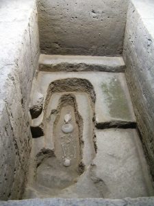
Banpo Village

Ian Armstrong | CC BY-SA 2.0
Banpo Village is a Neolithic site in the Yellow River Valley, east of Xi’an, Shaanxi Province, in the People’s Republic of China. The site was occupied from c. 4500-3750 BCE and covers almost 20 acres. Over 10,000 stone tools and artifacts, 250 tombs, six large kilns, storage pits, and almost 100 foundations of buildings have been excavated at the site.
Archaeologists have designated Banpo a type site, which means a representative model of a particular culture, in this case the Yangshao Culture, which flourished in the Yellow River Valley between 5000-3000 BCE. Banpo is a ditch-enclosed settlement that was surrounded by a moat. The homes were dug to three feet (1 meter) below ground level and the soil then used to fashion the foundations for the walls.
Walls were made of wood and topped by a thatch roof. Clay and wattle was then used to daub the walls for insulation, and the walls reinforced with fire-baked clay. Every building in the village was circular, and the village itself oval-shaped. The houses had hard-baked clay floors and front porches, which were shaded by the over-hanging roof of thatch. The cemetery was located outside of the village, beyond the moat, and so was the ceramics factory. The six kilns for firing ceramics at Banpo have all been found in one location outside the village, suggesting a kind of industrial complex there where communal pottery was shaped and fired. The inhabitants of Banpo did not use a potter’s wheel but shaped every ceramic by hand.
Ian Armstrong | CC BY-SA 2.0
The Yangshao Culture was matrilineal, meaning that women were in charge and one’s ancestry was traced through the mother’s line, not the father’s. While some have disputed this claim, every female’s grave that has been opened has more grave goods than the males; and no grave of the 250 discovered and excavated show any indication of a male chieftain but plenty of evidence for female leaders (based on the number of grave goods and the type). This points toward a matrilineal society in the strictest sense of women being in power and men subordinate.(12)
